Google patents system that turns text prompts into map data queries
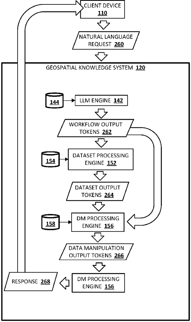
This filing describes a system that uses large language models to break down a user's text request into specific steps for finding map data. It automatically selects the right databases and writes the code needed to pull the information, such as locations or boundaries, without the user needing to know how to write database queries.
In the filing’s own words
Implementations are described herein for automatically generating multimodal geospatial workflows for accomplishing geospatial tasks. In various implementations, a natural language request may be processed based on generative model(s) such as LLM(s) to generate workflow output tokens that identify high-level actions for completing a geospatial task conveyed in the natural language request. First data indicative of the high-level actions may be processed using one or more of the generative models to generate dataset output tokens that identify responsive dataset(s) that likely contain data responsive to the geospatial task. Second data indicative of both the high-level actions and the responsive dataset(s) may be processed based on one or more of the generative models to generate data manipulation output tokens that identify data manipulation instructions for assembling data from the responsive dataset(s) into a response that fulfills the geospatial task.
What exactly they claim (claim 1)
1. A method implemented using one or more processors and comprising: processing a natural language request based on one or more generative models to generate workflow output tokens that identify high-level actions for completing a geospatial task conveyed in the natural language request; processing first data indicative of the high-level actions for completing the geospatial task and metadata associated with a plurality of candidate datasets based on one or more generative models to identify one or more responsive datasets for fulfilling the geospatial task; processing second data indicative of the one or more responsive datasets and the high-level actions based on one or more generative models to generate structured query language (SQL) instructions configured to extract geospatial data from the one or more responsive datasets; causing the SQL instructions to be executed against the one or more responsive datasets to generate a response that fulfills the geospatial task; and causing the response or data derived from the response to be rendered at a computing device.
Facts
- Company
- Google (X Development LLC)
- Official title
- GENERATION AND IMPLEMENTATION OF GEOSPATIAL WORKFLOWS
- Publication number
- US20260320104A1
- Application number
- 19694289
- Filed
- Jun 1, 2026
- Published
- Oct 15, 2026
- Inventors
- 6
- Claims
- 20
Classified under
G06F 16/387 Physics & computingG06F 40/284 Physics & computingMore from Google in AI & software
- Google patents video search that answers questions using AI descriptions Sep 15, 2026
- Google patents photo tool that removes people and their gear Sep 15, 2026
- Google patents AI that writes live meeting notes and summaries Sep 15, 2026
- Google patents AI tool that turns messy emergency notes into clear messages Sep 3, 2026
- Google patents AI that clicks through apps to finish tasks for you Sep 24, 2026
Summaries are simplified from the filing’s own abstract and first claim. A patent filing is not a product announcement.
Patent data and drawings: U.S. Patent and Trademark Office (USPTO). Nebula is not affiliated with or endorsed by the USPTO.